Since September 2022, the Geographic Section of the Land Information System has been upgraded and is now based on the most advanced Geographic Information Systems technology. This is the latest software, ARCGIS PRO, of the American company ESRI which in 1999 had developed the first computerised system of the Department, as far as the Geographical Section of the LIS is concerned, which was based on the ARCINFO software.
ArcGIS Pro is the latest professional desktop GIS application from ESRI. ArcGIS Pro empowers the user to explore, visualise and analyse data.2D Maps and 3D Scenes can be created. It provides access to apps, maps and data related to specific workflows from around the world, and tools to keep the user at ease in the field. Ultimately, users can share their work in the ArcGIS Online portal or the ArcGIS Enterprise Portal.
In ArcGIS Pro, a set of related tasks - consisting of maps, scenes, layouts, data, tables, tools, and connections to other resources - is usually organised into one Project. By default, a project is stored in its own folder in the system. Project files have the extension .aprx. A project has also its own geographical database (a file with the extension .gdb) and its own toolbox (a file with the extension .tbx)
Usually, a project starts from one of the four basic templates of the system or from a template that has been created for a specific organisation, such as the template created for the Department of Lands and Surveys.
There are several ways for the user to open his/her saved projects. All projects recently used can be accessed from the home page. The user can browse other saved projects to open them. A project may also be pinned to the home page to make sure it is always readily available.
The New System of the Department of Lands and Surveys
As of the 22nd of September 2022, the new system is running, and the old system, (ARCINFO/DIMS Application), ceased to operate from the 1st of August 2022.As a result, all the survey work of the Survey Branch is now processed through the new system.
Οι εμπειρογνώμονες της ESRI, σε συνεργασία, με την Ελληνική εταιρεία MARATHON DATA SYSTEMS, με την ομάδα του GIS του Κλάδου Διαχείρισης και Υποστήριξης του ΣΠΓ, με πολλούς από τους Λειτουργούς του Κλάδου Χωρομετρίας του Τμήματος και με τη στήριξη από την ομάδα των συναδέλφων του Τμήματος Υπηρεσιών Πληροφορικής έχουν αναλύσει και μελετήσει όλες τις διεργασίες του Κλάδου μας και έχουν αναπτύξει όλα τα απαραίτητα σενάρια (Workflows), με τα οποία θα διεκπεραιώνονται όλες οι εργασίες του Κλάδου Χωρομετρίας.
One of the most important objectives of the new system is to improve the procedures and operations of our Branch in terms of quality and speed, with a view to providing faster and better quality service to the citizen.
Factors that led the Department to upgrade:
- Existing system was outdated, running for more than 20 years
- There is almost no support available
- Multiple problems in implementing procedures
- Rapid growth of technology
- Modern technologies provide a user-friendly environment
- Modern, specialised and dynamic tools
Factors for choosing ArcGis Pro to upgrade:
- It belongs to ESRI the company that developed the first GIS system of the Department
- Modern Geographic Information System GIS
- Windows operating system
- Provides a pleasant and user-friendly environment
- It has a special Parcel management environment, the “Parcel Fabric”
- It features many specialised tools for the visualisation, analysis, recording and sharing of data
The most important objectives of the new System are:
- To create a Dynamic and User-Friendly Interface
- To upgrade the role of the users offering:
- A smooth flow of procedures
- Improvement of their complexity
- Reduction of the time needed to process a case
- To simplify the procedures
- The reduction of the circulation of files between Sections and Branches
- The reduction of the Branch’s workload.
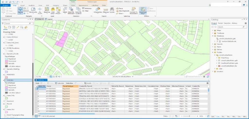
The picture below features the interface of the new system, which is clearly updated and obviously much more user-friendly.
The new system model of the Department of Lands and Surveys
Three key factors have been taken into account in selecting the appropriate system model:
- Best practices for parcel management, based on common land records management techniques.
- Interoperability and interconnection with other systems, such as Workflow Manager (WMX), Lands and Legal System, as well as the DLS Portal for further dissemination of data and
- How the Department intends to use the data in PARCEL FABRIC, both now and in the future.
The overall aim was to choose a solution that would satisfy all three of the above factors.
What is PARCEL FABRIC?
The new ARCGIS PRO software includes, among other important and useful functions, an interface, PARCEL FABRIC, which has the ability to manage data layers that are linked together by common features. Thus, PARCEL FABRIC is an integrated interface within ARCGIS PRO, which is based on specialised tools and provides the ability to manage and process data from different levels of information, which are linked together. In other words, they have common characteristics, which interact with each other.
For example, from the data available to the Department, PARCEL FABRIC can manage in its interface data such as parcels, buildings, easements and Leases, precisely because these data have common lines and common points. So by moving a line or a point from one layer then all the features of the layers above that, which contain that point or line, will be moved at the same time.
Hence, PARCEL FABRIC stores and manages groups of data that are connected to each other forming a network. When a PARCEL FABRIC is formed, the topology of the database is automatically created and there are also predefined topology rules for this database. These rules define the spatial relationships between the characteristics of the PARCEL FABRIC data.
Optimal solution and data structure
The structure of our data within PARCEL FABRIC and ARCGIS PRO in general, has been decided and implemented based on what has been outlined above. Thus, the data layers that currently exist in the existing system have been grouped into two classes:
- PARCEL FABRIC Feature Classes, being the data, which are part of and processed in PARCEL FABRIC and
- STANDALONE Feature Classes, being the data, which remain outside PARCEL FABRIC as separate data layers within ARCGIS PRO.
Attention has certainly been paid to the two most important layers, i.e., those containing the parcels; the Spatial Database layer (which in the old system was called SDB) and the Domain Cadastral Database layer (which in the old system was called DCDB).
As a result of the above and upon recommendation of ESRI experts, the data structure in the new system has been designed as the following:
- Sparse parcels have been separated from systematic parcels and stored as a Standalone Feature Class, outside the Parcel Fabric. This layer will no longer be updated. It will only exist for reporting and export of data if needed.
- The two layers of parcels, Spatial (SDB) and Domain Cadastral Database (DCDB), have been merged into a One Feature Class parcel layer, called PARCELS, which forms part of PARCEL FABRIC.
- Similarly, the other DCDB/SDB data layers have been merged in the same way. That is, DCDB Topo Lines with SDB TOPO Lines, DCDB Topo Points with SDB TOPO Points, DCDB Topo Area with SDB TOPO Area, DCDB Localities with SDB TOPO Localities, and so on.
- The Building Layer, Lease Layer and Easement Layer are stored within the Parcel Fabric, but in separate feature classes, as they share characteristics with the parcels.
- The rest of the data have been stored as Standalone Feature Classes, and shall be kept outside the Parcel Fabric.
Advantages of the layer merge
There are several advantages of merging the DCDB/SDB layers, such as:
- Data layers have been reduced by half,
- One level is updated at all times,
- The files will be completed more quickly,
- The Sector's workload will be reduced.
- There is a single database and a single map for all parcels across the entire territory of our country.
New layer data identification
Following the implementation of the above structure, there is now the issue of identifying the source of the data, in terms of whether these data have resulted from Digitisation or Adoption of New Projects, (Re-mapping/General Registration/Land Consolidation/Major Cases. Therefore, a new field, CATEGORY, has been added to the layer tables, containing the following data identification values:
- Digitized: Digitized parcels which were registered in the DCDB.
- Resurveyed: Parcels for which new LTM plans have been adopted.
- Surveyed: Digitized parcels to be adjusted according to survey work carried out following a survey file. More information on this subject is given in the following paragraph
Digitized parcels adjustment/alignment.
The Department's decision on the process of adjusting the digitized parcels to the local status has the long-term objective of improving the quality of the data. By implementing this decision, this procedure will now form part of all procedures used for collecting spatial data.
At the same time, the Department has also decided to adjust all digitized parcels for which survey work has already been carried out, as follows:
- Adjust the digitized parcels (Domain Cadastral Database - DCDB), to the adjacent resurveyed parcels of the Survey database, which was not possible under the existing system.
- Gradually, adapt the digitized parcels (Domain Cadastral Database - DCDB) to the existing sparse parcels, which as mentioned above will be stored outside Parcel Fabric in a separate Standalone Feature Class.
The digitized parcels that will be adjusted using the survey work will no longer be called "Digitized" but "Surveyed". That is, the value of these parcels in the “Parcel Category” field will now be “Surveyed”.
There are very dynamic and user-friendly tools that facilitate the process of adjustment. The use of precision data to improve data of lower precision is one of the most important advantages of PARCEL FABRIC. Available tools can be used to achieve this accuracy, aiming at eliminating duplicate entities, overlaps and gaps in the system.
During this process and the data revision/adjustment, it is possible to control the modifications (what is moved and what remains the same), without creating overlaps and/or gaps.
The Procedures
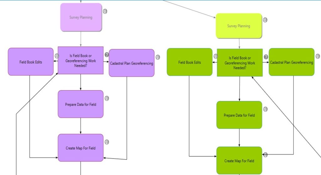
The workflows for all types of files, which are sent to the Survey Branch for processing, have been implemented based on the new system and the data model that has been selected for the Department. These files cover both cases for which survey work is required and cases for which it is not.
Thus, the following workflows have been implemented:
Cases for which survey work is REQUIRED:
- Demarcation
- Vertical Division
- Readjustment of Boundaries
- Amalgamation
- Updated Registration
- Towpath Removal
- Compulsory Acquisition/Requisition
- Horizontal Division
- Government Housing Leases
- Government Land Leasing/Vesting
- Exchange of Government Land with Private Property
- Intrusion into Government Land
- Investigation of Boundary Dispute
- Compulsory Acquisition of Right-of-Way
- Correction of Errors
- Adoption of New Plans (Article 50A) – Resurvey
- Adoption of New Plans – General Registration
- Objection to the Adoption of New Plans
- Land Consolidation
- Area Recalculation
Cases for which survey work is NOT REQUIRED:
- Possession/Inheritance
- Creation of Parishes
- Change of Administrative Boundaries
- Revision of Town Planning Zones
- Mass Update on Town Planning Zones
- Export of Data
- Issue of a copy of the Official Cadastral Plan
- Parcel Update regarding an Ancient Monument
- Insertion of Trigonometric Points
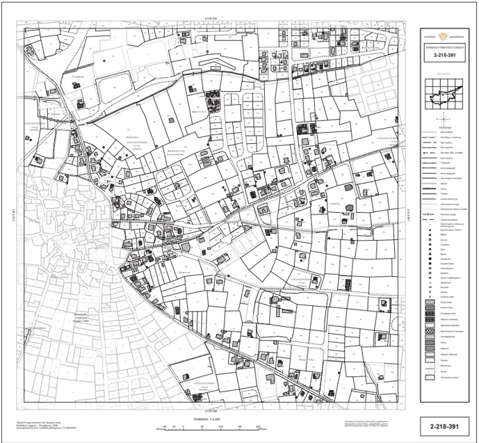
Redesign of the presentation of LTM Cadastral Plans LTM
The new technology and the new system tools gave the Department the possibility of redesigning the LTM Cadastral Plans, aiming at their faster preparation and their improved and more contemporary presentation.
As to their preparation, significant changes and improvements have been made, which may not be apparent to the public, but which have an internal impact on the Department, and the reduction of work done by the users.
The important thing, however, which is for the benefit of the citizen, is the fact that the boundaries of the parcels are more distinct than the other data shown on the plan. Clearly, this makes it much easier for the public to read the plan and immediately identify their property boundaries.
Due to the distinct display of the parcel boundaries in the plan, the placement of clefs has been eliminated, with some exceptions..
Moreover, the manual procedure of updating them performed by the Designer has been abolished and their updating/preparation is now performed automatically by the new system.