
Lands Information System
Lands Information System (LIS) - Definition
The redesign and automation of the Department's processes, together with the upgrade of its systems based on the latest flexible and stable technologies that provide enhanced unified functionality, are expected to lead to more efficient processes and to the provision of new services, thus contributing to improved productivity, new areas of growth and a more citizen-friendly approach.
The above is in line with the overall approach of the Republic of Cyprus regarding e-Government.
Architecture of the LIS
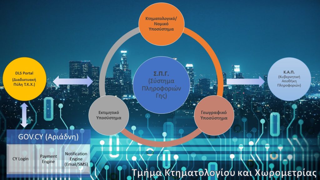
The LIS collects data from all over Cyprus and has the main database along with the district servers located in Nicosia (DLO Nicosia, DLO Keryneia, Nicosia Headquarters), Larnaca (DLO Larnaca), Ammochostos (DLO Ammochostos), Limassol (DLO Limassol), and Paphos (DLO Paphos).The LIS is based on a complex architecture, composed of a network of SUN servers connected to mainframe computers and workstations or Unix emulators running on personal computers and through Sunray servers/terminals. Applications are based on ArcINFO, ArcView, and Oracle with Oracle forms.
The main objectives and tasks of the Department are met by using the LIS. These are:
- The computerisation of land transactions
- The automation of methods and procedures
- The digitisation of existing cadastral plans and topographic maps. Automatic update of plans
- The gradual collection of digital land data from the re-survey programme
- The automation of valuation and re-valuation methods
- The automated case control and monitoring
- The provision of services to Government Departments and other organisations by extending the system to a National Lands Information System
LIS Sub-systems
Legal sub-system - covers all departmental operations relating to the registration, transfer, or inheritance of immovable property, management of government lands, personal and actual property easements, restrictions, sale contracts, forced sales and more. Read More
Valuation sub-system - supports and completes all cadastral transactions as well as transactions relating to the Valuation Branch. It handles applications for property valuations such as advisory, special, compulsory sale, and valuations for requisition and compulsory acquisition purposes by the Republic of Cyprus. In addition, the Valuation subsystem supports various valuation models for performing automated property valuations. Read More
Geographic (GIS) - Supports a number of procedures / transactions such as Division of Land, Amalgamation, Readjustment of boundaries, data export in order to be transferred to other interested organisations, calculation of plot area, etc. Furthermore, the Geographic Sub-system supports the production of cadastral plans and other thematic maps. Read More
Historic Background of the Development
of the Lands Information System (LIS)
1987
Sedunary Report
1993
Preparation of the Specifications
1995
Call for Tenders – Signing of the Agreement
1998
Development of the LIS
5 July 1999
Launch of the LIS (Legal/Valuation/Geographical)
up to 2012
Completion of the gradual integration of new geographical areas into the LIS
2014
Preparation of the DLS Information Technology Strategy
23 June 2016
Launch of the Online Platform “DLS Portal”
1987
Sedunary Report
Τοn Μάρτιο του1987 υποβλήθηκε στην Κυβέρνηση η πρώτη μελέτη από τον κ. Merv Sedunary με τον τίτλο ‘Study into the Computerization of Land Records in Cyprus’ (Supported by the Commonwealth Fund for Technical Co-operation) η οποία έγινε γνωστή σαν Έκθεση Sedunary’.
Αφού η Κυβέρνηση ενέκρινε την έκθεση Sedunary, προχώρησε στη συνέχεια στην υλοποίηση των εισηγήσεων της έκθεσης με την ανάκληση στην Κύπρο τετραμελούς ομάδας εμπειρογνωμόνων του οργανισμού SAGRIC για να αναλάβει την ετοιμασία στρατηγικού σχεδίου για την ανάπτυξη του Συστήματος Πληροφοριών Γης.
Ο κ. Sedunary ηγήθηκε τετραμελούς ομάδας Αυστραλών εμπειρογνωμόνων του οργανισμού SAGRIC, που ήρθαν στην Κύπρο και μελέτησαν την υφιστάμενη δομή και λειτουργία των διαφόρων Κλάδων του Τμήματος, καθώς και τις ανάγκες του Τμήματος για αυτοματοποίηση και απλοποίηση των διαδικασιών. Ο οργανισμός SAGRIC υπέβαλε στη συνέχεια ολοκληρωμένο στρατηγικό σχέδιο με τίτλο: Cyprus Land Information Project Strategic Plan, December 1989. Το στρατηγικό σχέδιο περιλαμβάνει λεπτομερή ανάλυση και εισηγήσεις για ανάπτυξη στην Κύπρο Συστήματος Πληροφοριών Γης, για να ικανοποιήσει τις ανάγκες του Τμήματος και άλλων Κυβερνητικών Τμημάτων και ιδιωτικών οργανισμών. Κατά τη διάρκεια της ετοιμασίας του στρατηγικού σχεδίου και της έρευνας που έκαναν οι εμπειρογνώμονες είχαν τη συνεχή υποστήριξη και συνεργασία των υπαλλήλων του Τμήματος οι οποίοι έδωσαν με πολύ αντιπροσωπευτικό τρόπο την εικόνα της υφιστάμενης κατάστασης και των υφιστάμενων διαδικασιών του Τμήματος τόσο από τεχνικής αλλά και από νομικής πλευράς.
1993
Preparation of the Specifications
Η Κυβέρνηση αποφάσισε στη συνέχεια, αφού ενέκρινε τις εισηγήσεις του οργανισμού SAGRIC που περιλαμβάνονταν στο στρατηγικό σχέδιο, να ζητήσει από τον οργανισμό αυτό την ετοιμασία προδιαγραφών και των απαραίτητων εγγράφων και όρων για προκήρυξη διεθνών προσφορών. Εμπειρογνώμονες του οργανισμού SAGRIC ήρθαν σε διάφορες περιόδους ακολούθως στην Κύπρο και αφού μελέτησαν με περισσότερη λεπτομέρεια επιτόπου όλες τις υφιστάμενες διαδικασίες, υπέβαλαν μια σειρά εγγράφων με γενικό τίτλο ‘Cyprus Land Information Project’, July 1990. Τα έγγραφα αυτά περιλαμβάνουν λεπτομερή ανάλυση των υφιστάμενων διαδικασιών του Τμήματος και λεπτομερείς προδιαγραφές για την ανάπτυξη στην Κύπρο του Ενιαίου Συστήματος Πληροφοριών Γης.
1995
Call for Tenders – Signing of the Agreement
Το Τμήμα αφού μελέτησε τις προδιαγραφές που ετοίμασε ο οργανισμός SAGRIC, τροποποίησε τα έγγραφα αυτά για να συνάδουν πλήρως με τις υφιστάμενες διαδικασίες του Τμήματος και τους κανονισμούς της Κυβέρνησης. Στη συνέχεια προκήρυξε διεθνείς προσφορές για την ανάπτυξη στο Τμήμα του Κυπριακού Συστήματος Πληροφοριών Γης. Μετά από αξιολόγηση των προσφορών που υποβλήθηκαν και των επιδείξεων που παρουσιάστηκαν, στις οποίες είχαν εμπλακεί υπάλληλοι του Τ.Κ.Χ., του Τμήματος Υπηρεσιών Πληροφορικής και εκπρόσωποι του οργανισμού SAGRIC, η Κυβέρνηση αποφάσισε να αναθέσει το έργο της ανάπτυξης του Συστήματος σε κοινοπραξία εταιρειών με επικεφαλής τη Δανέζικη εταιρεία “Datacentralen”. Στην απόφαση αυτή είχε ληφθεί υπόψη ο συνδυασμός της τεχνικής βαθμολογίας και του οικονομικού κόστους. Το έγγραφο συμφωνίας με τίτλο Agreement for the Development of an Integrated Land Information System υπεγράφη τον Απρίλη του 1995. Το έργο άρχισε να εκτελείται επίσημα από τον Σεπτέμβρη του 1995.
1998
Development of the LIS
Από τον Σεπτέμβρη του 1995 το Τμήμα συμμετείχε ενεργά στις διαδικασίες ανάλυσης των αναγκών του Τμήματος από το Σύστημα (System Requirements Analysis Phase) και στις διαδικασίες σχεδιασμού του Συστήματος (System Design Phase). Για το σκοπό αυτό το Τμήμα όρισε Λειτουργούς Συνδέσμους (Liaison Officers) οι οποίοι είχαν την ευθύνη να συγκεντρώνουν τις ανάγκες του Τμήματος, να αναλύουν τις υφιστάμενες διαδικασίες, να αξιολογούν οποιαδήποτε έγγραφα ετοιμάζονταν από την Κοινοπραξία-Datacentralen και γενικά να λειτουργούν ως σύνδεσμοι μεταξύ του Τμήματος και της Κοινοπραξίας και επίσης με το Τμήμα Υπηρεσιών Πληροφορικής (Τ.Υ.Π.). Οι Λειτουργοί αυτοί βρίσκονταν σε συνεχή επαφή και επικοινωνία με τον Διευθυντή ‘Έργου (Δ.Ε.) και οποιεσδήποτε ανταλλαγές εγγράφων γίνονταν σε συνεργασία με το Τ.Υ.Π.
5 July 1999
Launch of the LIS (Legal/Valuation/Geographical)
up to 2012
Completion of the gradual integration of new geographical areas into the LIS
2014
Preparation of the DLS Information Technology Strategy
23 June 2016
Launch of the Online Platform “DLS Portal”
Interconnection of LIS with other Horizontal Applications
DLS-PORTAL interacts with the horizontal Government Gateway GOV.CY (ARIADNI) for identification, payment and messaging purposes. This interconnection provides the following features:
- Single access (CY Login)
- Online transaction payment
- Online transaction notifications (email, sms)
- Direct communication between the DLS and the Civil Registry & Migration Office/ Registrar of Companies & Official Receiver (B2B)
Interconnection of LIS with the Government Gateway GOV.CY (ARIADNI)
The Government Gateway (Ariadni) enables users to use the electronic services (e-Services) available from the Republic of Cyprus via the internet. The interface provides the following features:
- Single access (CY Login)
- Online transaction payment
- Online transaction notifications (email, sms)
- Direct communication between the DLS and the Civil Registry & Migration Office/ Registrar of Companies & Official Receiver (B2B)
The GDW maintains data from the various information systems of the Government Departments/Services which can be used to take valid and timely decisions, to draw conclusions and to formulate the policy of the Public Service. The LIS provides information for:
- The development of a Central Database
- Analysis/Processing
- Linking interrelated information and providing answers to governance questions
DLS & Government Data Warehouse (GDW)

The National Open Data Portal (data.gov.cy) is a resource where most Public Bodies of Cyprus publish their data for further use. It offers to the user an easy and quick way to find and access processed or raw data generated by the public sector, in order to reuse them and exploit them beyond their intended purpose, for the development of innovative services/products with added value. The DLS provides statistical, hydrographic and other data to the National Open Data Portal.